Join War on the Rocks and gain access to content trusted by policymakers, military leaders, and strategic thinkers worldwide.

Are India and China on the path to war in the Himalayas? Or will recent tensions over their disputed border fade into history like dozens of other standoffs that were resolved diplomatically?
Last month, Indian outlets reported that hundreds or even thousands of People’s Liberation Army (PLA) soldiers were digging positions on the Indian side of the Line of Actual Control — the de facto border between the two countries — in the mountainous region of Ladakh, in the western sector of the India-China border. Although government officials in New Delhi were slow to confirm the existence of a new dispute, PLA soldiers may have established camps and destroyed Indian infrastructure in territory that was not previously part of the long-running disagreement over the location of the Sino-Indian border.
Since the end of a short and bloody border war in 1962, skirmishes and land grabs in forbidding and difficult operating environments have become standard fare for soldiers in China and India. Earlier this month, eleven Indian and Chinese soldiers were injured in a fistfight at Naku La (4,500 meters above sea level), when patrols clashed northwest of the tri-junction border between the Indian state of Sikkim, the Kingdom of Bhutan, and China’s Tibet Autonomous Region. In 2017, cell phone video captured a spectacular brawl at Pangong Lake, one site of the present dispute. Earlier that same year, much larger units engaged in a multi-month standoff on the Doklam plateau in Bhutan near the tri-junction border. Present day tensions over road construction and patrol incursions may follow a well-rehearsed script, but given the history of conventional warfare over the border and given that both countries are nuclear powers, military adventurism at high altitude carries risks that far exceed broken noses and injured pride.
How dangerous are these frequent border disputes and standoffs, whether they begin as spontaneous patrol clashes, infrastructure building projects, or, as prominent scholar of South Asian security Ashley Tellis has recently argued, as more carefully planned attempts to amend the political map in the Himalayas?
Though the situation on China and India’s Himalayan border facilitates frequent disputes and small land grabs, any individual conflict has relatively low potential to escalate into a conventional war. Difficulties of fighting in the high altitude and harsh terrain make large changes to the territorial status quo very costly. Reversing an adversary’s small land grabs is not worth the prize. Absent misinterpretation or miscalculation — always possible during militarized disputes — neither side is likely to escalate the current situation. As a result, the decades-old border dispute between India and China remains far from resolution.
What’s So Hard About the Altitude?
The immediate causes and consequences of dustups between these nuclear-armed militaries are shaped by the unusual physical environment, which varies widely along the length of the China-India border. The altitude and infrastructure at the border impose substantial constraints on both armies, incentivizing localized instability and an enduring possibility of spontaneous tactical clashes. However, the environment also provides scant opportunities for major strategic gains by either side, and therefore creates a low likelihood of major escalation. Recent events in the Himalayas may portend the development of a Sino-Indian situation that reflects an “ugly stability” between India and Pakistan: persistent low-level conflicts and political-military crises that simmer below the threshold of conventional war. Neither India nor China have a rational incentive to escalate in part because there is no reason for optimism about the possibility of a quick and decisive victory, but persistent high tensions create frequent opportunities for miscalculation and mistakes that could spiral out of control.
Operating above 4,000 meters, as both the Indian Army and the PLA are well aware, changes nearly every aspect of warfare. Soldiers take days to acclimatize to any altitude above 2,400 meters (slightly higher than Santa Fe, New Mexico), so the rate at which reinforcements arrive may be slower than the speed of their means of transport. The risks of ascending too quickly are dire: Even young and healthy soldiers are at risk from “acute mountain sickness,” pulmonary edema, and cerebral edema. Ascending slowly diminishes but does not eliminate health risks. During the 1962 Sino-Indian border war, some Indian units skipped acclimatization and proceeded directly to extreme altitudes in Kashmir and Sikkim. Nearly 15 percent of soldiers in the rushed units developed high altitude pulmonary edema, a leading cause of altitude-related fatalities that can progress from initial symptoms to death in as few as 12 hours for even healthy individuals.
After acclimatization, soldiers move slower at high altitudes than they do at sea level, must carry lighter loads, and consume more calories to sustain themselves. The diesel engines that power trucks and armored vehicles, likewise, are less efficient and less powerful at 4,000 meters. Resupplying soldiers under these conditions is a massive undertaking. Doctrinal standards from Argentina’s Mountain Infantry, for example, indicate that a single company consumes 5000 kilograms of supplies per six days of operations, or, roughly one sea-level maximum-load sortie for an Mi-17 helicopter (common in the Indian and Chinese armies) per week. Given that all helicopters have lower maximum loads at high altitude, however, sustaining a single brigade for a week at high altitude would require roughly 24 sorties for a Mi-17 — each company would require two sorties per week. Sustaining large forces at high altitudes for extended periods of time, like the brigade-sized units China has allegedly surged toward and — in smaller numbers — across the Line of Actual Control, would be extremely costly and potentially infeasible during the winter as flying becomes riskier and road passage less efficient.
Even shooting is harder. The Indian Army learned during the Kargil war in 1999 that rifle rounds and artillery shells fly differently at high altitudes. Artillery batteries need altitude-specific firing tables to put shells on their intended targets, and infantry soldiers need to re-sight weapons and practice in the thin air. At the extreme heights in Ladakh and Sikkim, soldiers’ eyesight changes. Low air pressure can induce corneal distortion (causing nearsightedness), diminish low-light vision, and degrade depth perception.
Even if altitude were not a factor, the terrain along the India-China border would still complicate military operations. The Himalayan Plateau is not flat like the central front in Europe, nor necessarily tank-drivable like the deserts in Iraq or along the border between western India and southern Pakistan. A relief map of the Doklam plateau (disputed in 2017) shows the extent of the terrain challenge that both armies face. Ridges on the “plateau” rise as high as 4,300 meters, over valley floors that, less than 10 kilometers of map distance away, are as low as 2,400 meters. The situation in Ladakh is similar, and in both sectors, China’s side is generally “uphill” and flatter. Pangong Lake sits at an already-high 4,100 meters, but the peaks that rise less than 10 kilometers from its banks top 6,500 meters — higher than the operating ceiling of many helicopters.
Climate, too, poses unusual challenges for military operations. While the summer weather in Ladakh is pleasant enough for tourist camping, winter lows in the minus 10s and 20s Fahrenheit are not uncommon, and high winds are frequent. Winter temperatures bring the threat of frostbite and hypothermia-related attrition of forces, and even render some equipment useless as lubricants freeze and barrels on tubed artillery may crack. In eastern sectors of the border, different climate challenges complicate military operations: The monsoon rains in Arunachal Pradesh (some of the heaviest in the world) regularly cause landslides that cut lines of communication and render troop movement impossible.
Figure 1: Relief map of the Doklam plateau and tri-junction border between India, China, and Bhutan. The marked elevation is Mount Gipmochi, which rises from the southwestern corner of the plateau. The river valley visible on the left is the downstream reaches of the Chumbi Valley, China’s main approach to the plateau.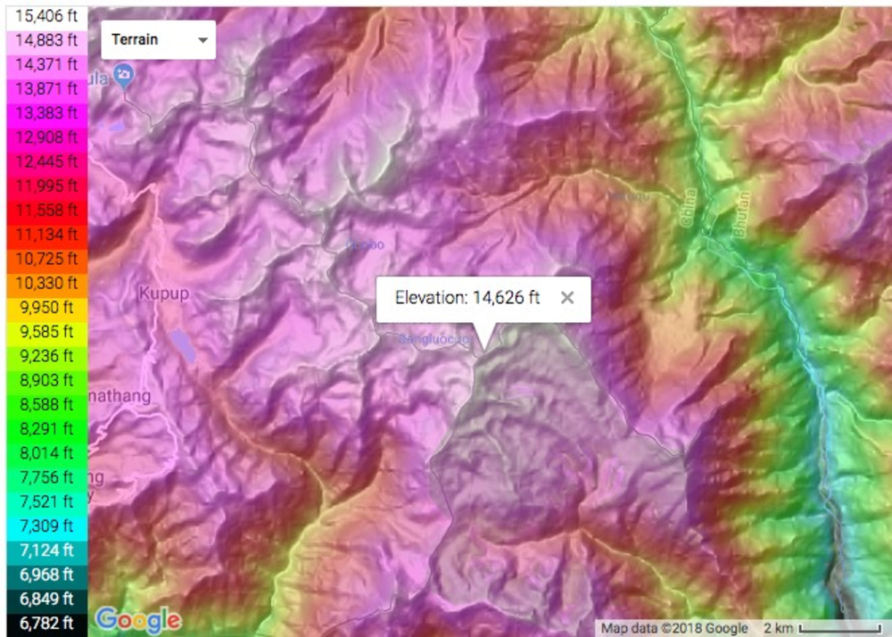
Source: Generated by the author using Topographic-map.com.
If, as Clausewitz wrote, “in war the simplest things become very difficult,” then war at altitude borders on impossible. Increased friction in key tasks during a high altitude dispute — moving to the contested area, tactical movement on the battlefield, and sustainment operations — shapes the way standoffs and skirmishes develop, and constrains the possible consequences. Terrain and environment, as the third belligerent in the Sino-Indian border dispute, promotes low-level instability but constrains escalatory potential.
Strategic Effects of Altitude and Terrain
While altitude and terrain are impartial forces, they interact differently with the strategic positions of the Indian and Chinese armies along different sectors of the border. The difficulties of fighting at altitude — namely the long lead-time to move from garrison to the putative battlefield — give both sides an incentive to make expensive preparations necessary to arrive quickly at the site of a dispute. India forward deploys much larger forces than China; locally garrisoned Indian soldiers outnumber the PLA both in the Sikkim and Ladakh sectors but as India has the “downhill side” of the border in all sectors, the nearby units are often stationed at low altitudes. China, conversely, has far fewer soldiers permanently based near the disputed border sectors and has instead focused on developing expensive infrastructure to speed arrival of reinforcements, enabling smaller forces at the border to initiate and respond very quickly in a nascent dispute. In the current dispute, China also used the cover of large, seasonal exercises at altitude on the Tibetan plateau to move reinforcements toward dispute sites in Ladakh. Variations in terrain and pre-existing border road infrastructure on each side make this task more difficult in some sectors and easier in others. Ultimately, terrain, climate, and altitude contribute to a strategic environment where, in certain sectors, China could surge infantry and light armor forces to a dispute site more quickly than India. However, there is no sector where China can rely on India’s logistical difficulties indefinitely.
At Doklam, for instance, the PLA likely cannot hold a substantial force ratio advantage for any longer than two weeks, which is scarcely enough time to meaningfully advance, or engage in substantial infrastructure building. The window of opportunity may be even smaller if India has forward deployed large units to high altitudes near the Nathu La border. China’s situation would be even worse in the highly unlikely case that India were to accept the possibility of escalation and begin to attack Chinese reinforcements on Chinese soil before they reached the plateau. India, from its border outpost at Nathu La, has outstanding overwatch and substantial pre-placed artillery covering China’s single approach to Doklam through the Chumbi valley.
In short, the logistical difficulties of fighting along the Sino-Indian border create multiple windows of opportunity at the tactical level, but relative stability at the strategic level. Leaving aside political considerations, continued opportunism and micro-scale land grabs — which could not realistically be large enough to resolve the entire border dispute — are likely to continue for years to come, but not escalation to large scale conflict.
Altitude Strengthens the Incentive to Move Early
Most armies follow a template called “graded ascent” to acclimate their soldiers to high altitude, moving soldiers to steadily higher altitudes over a period of up to 10 days. Doing so is critical for preventing combat power degradation from altitude sickness. For both China and India, however, the graded ascent timeline is the limiting factor for surging forces toward a border dispute. Once the need for more forces at the border is identified, neither army can do much to expedite movement past the rate dictated by graded ascent unless they are willing to accept substantial non-combat attrition in improperly acclimatized units. Travelling lighter and in smaller groups may speed mobilization in normal operations, but there is no shortcut for acclimatization.
The languid pace at which soldiers adjust to altitude gives both India and China incentives to start mobilization very early in a crisis, rather than waiting to see how a situation develops politically. This is especially true for the “downhill side” in a particular sector — for Sino-Indian border contingencies, the most important measure of distance is not kilometers from the engagement, but meters below the engagement, because the tightest logistical constraint upon arrival at the battlefield is acclimatization time, not driving distance.
Force Ratio Gaps Open, and Then Close
In the Sikkim sector, the altitude advantage clearly rests with China. The PLA Western Theater Command garrisons six brigades (including independent artillery and air defense brigades) at altitudes above 3,000 meters on the Tibetan Plateau. The Indian Army’s entire XXXIII corps comprising three full-sized infantry divisions with organic artillery plus corps-level assets, is garrisoned much closer to the border in Sikkim than any major PLA units, but their division-level garrisons are no higher than 1,650 meters and as low as 140 meters at Siliguri. Anecdotal accounts suggest that India pre-acclimatizes and forward-deploys some formations from XXXIII Corps, but pre-acclimatized soldiers and paramilitary forces may number in the dozens or hundreds, not thousands. Pre-acclimatized units are likely larger in the Ladakh sector, though open source information on these patterns is scarce. Even though India’s major infantry formations are closer, China’s infantry formations could arrive at a border dispute faster.
Figure 2: Indian Army’s XXXIII Corps Division-level garrisons, plus the Corps headquarters and a battalion at the Doklam Plateau, as of the 2017 Doklam dispute.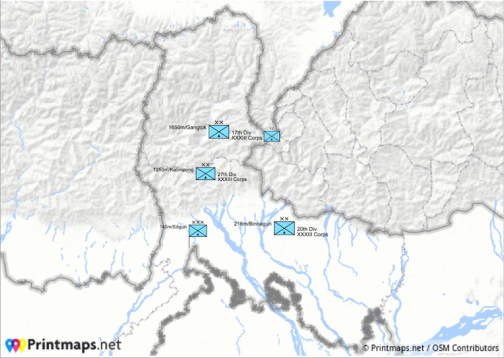
Source: Generated by the author using Printmaps.net.
The defender’s imperative in a border dispute is to minimize the number of days that an adversary maintains an advantageous force ratio at the site of a dispute. Out of concern for escalation, defenders should be cautious about striking first to interdict adversary reinforcements on their own territory before they have crossed the border. The target in question is the Doklam Plateau, disputed in 2017, which sits at an average altitude of 4,200 meters.
Sikkim is commonly thought to be India’s strongest sector, given the presence of the entire XXXIII corps in a state slightly larger than Delaware, and India’s general numerical advantage over Chinese forces east of Nepal. Physical terrain, though, favors China in the Sikkim sector more strongly than in either Ladakh to the west or Arunachal Pradesh to the east. Take the situation in Ladakh, the site of the current dispute, for comparison. Despite recent improvements to the Dalut Beg Oldi road — which may have sparked the most recent border tensions — India’s border infrastructure in the Western sector in Ladakh is inferior to China’s, impeding Indian reinforcements from reaching their destinations quickly. The starting altitudes for reinforcements, though, are much higher in the Western sector than in Sikkim. The XIV Corps in the Indian Army’s Northern Command, for instance, is garrissoned at 3,500 meters in Leh, and maintains permanent encampments at altitudes up to 4,200 meters in Leh district. China’s local advantage in acclimatization is minimal in these sectors, but the logistical friction of ground combat at altitude in mountainous terrain still encourages hair-trigger reactions by both armies. In the air domain, China may be at a disadvantage since maximum takeoff weights for fighter and attack aircraft are inversely proportional to takeoff altitude: Higher airfields decrease the usable payload capacity and fuel load of jets.
China’s advantage in pre-acclimatized infantry units creates a different situation in Sikkim. In the absolute best case for China, a well executed Chinese mobilization creates no more than a ten-day window in which the PLA has at least a four-to-one advantage in ground forces at a dispute along the Sino-Indian border. India’s qualitatively superior mountain infantry forces, assuming they mobilize within 24 hours after the first signs of Chinese forces moving toward the border, take nearly 10 days to arrive at the plateau. However, their arrival closes the force ratio gap. Stationing Indian forces forward of their garrisons, as the Army did during the Doklam crisis in 2017, changes the timetable surprisingly little. Forward deployments bring Indian units closer to Doklam, but usually not much higher. In the Sikkim sector, unlike what appears to have happened in Ladakh, China may not be able to accomplish much in terms of revising the political map of the border in the 10 days it takes Indian forces to arrive, especially given India’s organic advantage in artillery in the sector. The air balance is more or less a wash: Indian Air Force support is generally acknowledged to be qualitatively superior to the PLA Air Force resources in the Western Theater Command both in terms of aircraft and personnel, but the PLA’s ability to surge air defense assets including modern surface to air missiles to the Doklam Plateau early in a crisis likely diminishes India’s advantage. India’s supposed advantage in the Sikkim sector depends in part on ground attack air force capabilities. Availability of China’s air defense assets early in a crisis surely diminishes the impact of India’s air power.
Maintaining the territorial status quo and strategic stability in the Sikkim sector of the Sino-Indian border, as one example, requires de-stabilizing postures at the tactical and operational levels. Ensuring strategic stability requires rapidly matching the other side’s mobilizations, in an environment where doing so is slow and difficult. Both sides stand prepared to surge large forces (perhaps as large as the disputed areas can tolerate) early in a developing crisis in order to counteract the logistical and physiological constraints imposed by the terrain and altitude. If both sides surge effectively, however, the attacker’s window of opportunity is probably too small to be useful for strategically meaningful revisions to the status quo.
A Bird’s Eye View
While the Himalayan terrain incentivizes boldness and adventurism at the tactical level, it simultaneously dampens the possibility for small disputes to escalate into large-scale, shooting war. Altitude and terrain along the Sino-Indian border always impose severe constraints on the armies trying to defend or revise the territorial status quo. Hyper-local discrepancies in the rate at which China and India can surge reinforcements to high-altitude disputes create incentives for both sides to maintain high alert, and to begin mobilization early in potential crises. At the same time, the interactions of each army’s force posture with the physical terrain tend toward a stalemate at the strategic level: Wherever favorable force ratios can be generated, they can be reliably matched by the adversary after relatively short delays. Any territorial claims that either side can grab and hold are likely to be too small to resolve long-running border disputes.
In Ladakh/Aksai Chin, where Indian and Chinese forces are facing off today, the constraints of altitude, climate, and mountainous terrain are even more severe than in Sikkim. Reinforcements on both sides take time to acclimatize to the 4,300 meter elevation, resupply by helicopter or truck is difficult and potentially uncertain even during good weather, infrastructure is poor pending efforts on both sides to build more reliable roads, terrain is extremely rugged and varied, and winters — should the dispute last that long — are brutal. Any window for China to capitalize on a temporary force-ratio advantage is closing, or has closed. If, as news reports suggest, China has secured multiple small pockets of territory in Ladakh, India is faced with no good options. However, without an appetite to greatly escalate the conflict or expand it to other pockets of territory, India can only negotiate or make its peace with China’s small gains. Neither side has reasonable incentives to escalate the dispute further. Barring mistakes or miscalculation, the PLA incursions at Pangong lake, Galwan, and the Hot Springs will be the latest entries in a long list of disputes that did relatively little to resolve the large disputes over the India-China border.
Aidan Milliff is a PhD candidate in the MIT Department of Political Science and an affiliate of the MIT Security Studies Program and the Lakshmi Mittal and Family South Asia Institute at Harvard. His research focuses on behavior and decision-making during violence, emotions and in political violence, and South Asian security.
Image: Flickr (Photo by Shayon Ghosh)
CORRECTION: A previous version of this article stated, “Earlier this month, eleven Indian and Chinese soldiers were injured in a fistfight at Nuka La.” This was incorrect. The fistfight occured at Naku La.